The Clapham Society Local History Series 9
Geophysical Surveys of Clapham sites by Stratascan in 2011
by Michael Green RIBA FSA
BACKGROUND
The illustrations: Please click on thumbnail or text link to see a larger version.

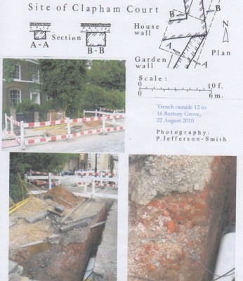
This important archaeological exercise took place as a direct result of the discovery of foundations in the manor house area by Peter Jefferson Smith in August 2010. The remains were found in service trenches in Rectory Grove and raised the question of what part of the Elizabethan manor did they come from? The Local History Sub-Committee decided to call on the services of Stratascan who used non-invasive Ground Probing Radar to trace archaeological remains which were otherwise inaccessible due to paved areas or heavily cultivated gardens. The committee also decided that while the Stratascan team was around it should also examine the sites of the Norman manor house at the west end of St Pauls church and the 17th century Clapham Place in The Chase.
The geophysical survey team from Stratascan carried out the work in the spring and summer of 2011, the final report being submitted in September of last year. It was evident that the sites had been much disturbed during the post-medieval period and the results indicated that surviving foundations were in a poor state of preservation. Nevertheless, important discoveries were made on all three sites, which enabled these mansions to be precisely located and some of their internal arrangements to be plotted.
SITE METHODOLOGY
The most suitable technique to achieve the desired objective was radar. Radar is suited for use in small areas due to the high resolution of data it is capable of gathering compared to other methods, and it is not adversely affected by above ground urban clutter.
A short pulse of energy is emitted into the ground and echoes are returned from the interfaces between different materials in the ground. The amplitude of these returns depends on the change of velocity of the radar wave as it crosses these interfaces. When plotted as a vertical section these readings show up as discrete features as illustrated on a typical area plot (Radargram 3: Area A) in St Pauls churchyard (Fig. 1A). Although the geophysical structures identified as part of the Elizabethan manor (Clapham Court) and the Carolingian house (Clapham Place) can be attributed with some certainty, thanks to recent associated archaeological discoveries, the same cannot be said of the building discoveries at the west end of St Pauls church. These substantial structural remains really need to be examined by archaeological excavation before what is at present only a hypothetical theory can be finally validated.
ST PAULS CHURCHYARD
The lost Clerke tomb sculptures
The search for the postulated Norman manor house was only one of a number of matters of interest connected with St Pauls that Peter Jefferson Smith and I wanted to follow up. The last remnants of the medieval church were pulled down in 1814 and the splendid funerary monuments of the Lords of the Manor were dumped in the manorial burial vaults around the old church. Those of the Atkins family were retrieved by J H Grover in 1886 and are on view at St Pauls. However, most of the Bartholomew Clerke monument is still missing, and may still survive in one of the unlocated burial vaults (Green 2009, 127). It was proposed that initially a strip of churchyard around the outside of the existing church should be examined for missing vaults or the entrance steps to vaults underneath the present church. The survey was carried out on 1.3.2011 by Richard Fleming and Abi Tomkins of Stratascan. The work was greatly assisted by the discovery of an old plan of the churchyard carried out by the Borough Engineer of Wandsworth, showing the exact position of every tomb and structural feature. This enabled many of the geophysical anomalies to be identified as graves and in one or two cases large vaulted family tombs. A large tomb (6 ft. by 20 ft.) of this type (Fig. 1 B and Fig. 3.7) near the north west corner of the present church may perhaps be that of Sir Dennis Gauden and his family of Clapham Place in the 17th century. Unfortunately no definite traces of entrance steps to a hitherto unlocated burial vault underneath the northern side of St Pauls were discovered by the geophysical survey.
The site of the medieval church
One outstanding issue that needed to be resolved was the alignment and exact position of the medieval parish church in relation to the present St Pauls. In Historic Clapham I stressed the lack of evidence for the relative positioning of the two churches (Green 2009, 116). However a substantial area of foundations identified by the geophysical survey (Fig. 1 B) 15 ft. long by 7 ft. wide appears to have some connection with a block of walling which was incorporated into the entrance of the old church where it is shown on the plan of 1776. This walling revealed by the geophysical survey is at a slight angle to the present St Pauls. Originally I thought that the masonry on the plan was part of the old manor house, but it is evidently later since the manor east wall runs beneath it (Fig. 3.8). It seems likely that these massive walls and foundations belonged to the late medieval church tower at the west end of Holy Trinity shown on a drawing of John Ogilvy of c. 1675 (Green 2009, fig. 68, 119).
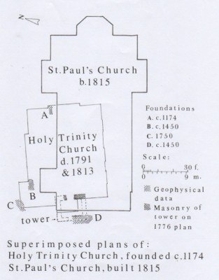
The next step was to overlay a plan of the existing building and geophysical results with that of the earlier Holy Trinity plan as recorded in 1776. These various anomalies then all fell into place, and we now have for the first time an accurate record of the relationship between the two churches (Fig. 2). The geophysical survey as it progressed round the church noted a few of what it termed shallow, planar anomalies. These appear to be stubs of footings which were not cleared away when the last remnants of the old church (i.e. the former north aisle) were demolished in 1814, and during subsequent grave digging. The old church, which was much smaller than the present St Pauls, can now be seen to fill the north-west area of the present building and extended out into the graveyard. There is a 3.5˚ difference in the orientation.
The most significant of those remains are:
Fig. 2A. Chancel walling (6 ft. by 3 ft.) which is all that survives of the Faramus chapel built c. 1174.
Fig. 2B. North aisle walling (8 ft. by 3 ft. 6 in.) dating to c. 1450.
Fig. 2C. Corner of the vestry built by William Hewer in 1715.
Fig. 2D. The west wall and foundations of the medieval tower, c. 1450. About 20 ft. square externally, it was centrally placed on the west front of the old Holy Trinity church, with an entrance porch at the bottom and a steeple above. The inner, eastern wall of this tower is that shown on the 1776 plan of the church, and it is evident that the medieval doorway in this wall was retained as the main west door of Holy Trinity.
The positioning of St Pauls church ensured that the new structure was clear of the north aisle of the old church, perhaps only partially demolished at the time, while at the same time the burial vaults under the nave and south aisle of the old church continued in use.
THE NORMAN MANOR HOUSE
Site
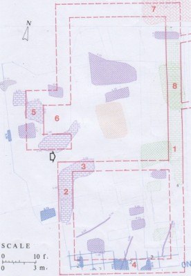
The theoretical site of this building, at the west end of the old parish church of Holy Trinity, was postulated in my book Historic Clapham (Green 2009, 116). It appears to have been substantiated by the Stratascan geophysical survey. The remains of the substantial masonry structure identified with the manor house was a rectangular building with external dimensions of 37 ft. by about 80 ft., although the exact northern limit is uncertain. The eastern side of the building, 47 ft. long, was well preserved and retained patches of the internal floor on its west side at a depth of 2 ft. The wall, or perhaps more likely a foundation trench filled with masonry rubble, was 4 ft. 6 in. wide (Fig. 3 .1).
Elsewhere the masonry remains were much more fragmentary due to grave digging since the late 15th century. Their interpretation depends on what type of mid-twelfth century manorial building we are looking at here.
The First-floor Hall
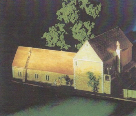
Mid twelfth century Norman houses of moderate size typically consist of a stone hall raised on a basement or cellar, either vaulted or, more likely here, with a wooden ceiling. This arrangement would provide safe storage accommodation below, and raise the living rooms to a defensible height above the ground (Wood M. 1965, 18 and 19). A 13 ft. length of the western wall (Fig. 3.2) was recorded by the geophysical survey (also 4 ft. 6 in. wide) together with possible fragments of the southern wall (Fig. 3.4). A stub of internal walling (Fig. 3.3) might suggest that the first floor plan was divided into a northern hall 28 ft. by 42 ft. internally, with the solar (private quarters of the Lord) at the south end 28 ft by 25 ft.. There appears to have been a central entrance on the west side. To the north of it was a large masonry projection (Fig. 3.5) 9 ft. by at least 14 ft., which may have been the chimney breast of the hall fireplace. However it is not central to the adjacent hall. Another alternative might suggest the possible base to an outside staircase to the hall, which is the usual arrangement for Norman first-floor halls. Yet another possibility is an internal spiral staircase (Fig. 3.6). This feature raises the possibility that it may have had more than one type of use during the 300-year life of this building. In short the new geophysical evidence supports the theory of a large masonry building at the west end of the early church, interpreted here as the Norman manor house, but its internal arrangements and their functions must remain speculative until confirmed by archaeological excavation which in the circumstances is highly unlikely (Fig. 4).
The important results of the geophysical survey in St Pauls churchyard could not have been obtained without the generous support of the vicar, the Reverend Deborah Matthews, her assistant Nicola White, and the Churchwarden, Roger Hird. The Clapham Society and I are most grateful for their help.
THE ELIZABETHAN MANOR HOUSE CLAPHAM COURT
The Site
Unlike the Norman manor house of Faramus of Boulogne, the site of the splendid mansion, Clapham Court, built by Bartholomew Clerke c. 1580, has always been approximately known.
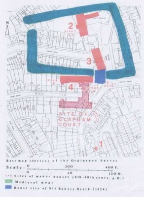
The ancient manor house at Clapham appears to have passed through four phases (Fig. 11), each of which required a completely new site and building complex (Green 2009, 55-60, 132-141).
1. The Saxon Hall of Ealdorman Alfred. Built later 9th century.
2. The Norman manor house and chapel of Faramus of Boulogne. Built earlier 12th century (see above).
3. The late medieval manor house of Thomas Gower. Built mid 15th century.
4. The Elizabethan manor house of Bartholomew Clerke. Built c. 1580. It was the site of this building that was investigated by Stratascan in 2011.

Peter Jefferson Smith discovered and photographed a corner of the manorial complex in August 2010 (Fig. 5) in a service trench in the street outside the front of No. 14 Rectory Grove. An analysis of old plans and early 19th century views suggested that it might be the southeast corner of a Jacobean house built by Sir Robert Heath in 1624 (Fig. 6). Alternatively it might have been the corner of the late medieval manor complex of Thomas Gower. In view of the heavily built-up character of the area, only a geophysical survey would be likely to solve the archaeological problem. An important observation by Peter Jefferson Smith, who lives locally, was that the back garden areas from No 35 Turret Grove eastwards were on a built-up artificial terrace, which would have provided a suitable site for the 1580 building range.
Given the area of land involved, it was necessary that a number of discrete sites relating to the Elizabethan manor house site be examined in March and August 2011 by Stratascan.
Rectory Grove Phase 1 (March 2011).
No. 24 (Area 2). Gareth Clarke.
No. 16 (Area 4). James and Anne Bromwich.
No. 18 (Area 3). Ruth Dupré and Michael Glover.
I am most grateful to the above owners for allowing the geophysical survey to take place in their back gardens, and to Adam Tidbury (No. 9 Rectory Grove) for initially contacting them.
Turret Grove Phase 2 (August 2011).
No. 39. Hester and Richard Greenwood.
I am likewise indebted to the Greenwoods for allowing their garden to be tested in August 2011.
It was initially intended to include No. 41 Turret Grove in this exercise, and any future geophysical survey should include this and any other available sites in the immediate vicinity of Turret Grove.
The Geophysical Survey
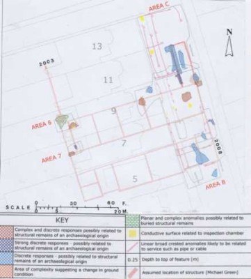
The three areas available in the back gardens of Nos. 14, 16 and 18 Rectory Grove for geophysical study were orientated north-south on the likely alignment of the Clerke building. They were deliberately organised in this way so as to cut the line of any east-west walls. In all three areas there were strong discrete responses possibly related to structural remains of an archaeological origin (Fig. 7).
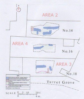
Fortunately in area 2 (no. 14) there was clear evidence of a massive chimney stack 16 ft. 6 in. wide, projecting 5 ft. on the south side of a wall, which here was 3 ft. wide. This give-away feature can be identified with the stack shown on the south face of the building in various late 18th and early 19th century engravings of which that by J C Buckler (1823) is probably the clearest (Fig. 9). This lucky discovery provided not only the alignment of the Clerke building, but settled the debate about the corner of the building shown up in the service trench in 2010. It was almost certainly the south east corner of the Jacobean house built by Sir Robert Heath in 1624 (Fig. 6). This discovery also proved that the 1580 manorial range lay 23 ft. further south than originally postulated in Historic Clapham (Green 2009, pl. 16). It was laid out on top of the terrace identified by Peter Jefferson Smith, and south of the medieval moat (Fig. 11).
So what was then the significance of the load-bearing walls in areas 3 and 4? (Figs. 7 and 10). At the very least they indicate a large building to the south of, and at right angles to, the Clerke range, whose width and length was uncertain. In Historic Clapham I suggested that the 1580 range with its octagonal viewing tower overlooking the manorial park (Fig. 8) was only part of a larger planned complex, of which those to the south were either later pulled down or never completed (Green 2009, 139-140).
The second phase of the Stratascan survey in August 2011 concentrated on finding the west end of the Clerke range (Fig. 10). It was calculated that it probably lay in the back gardens of Nos. 39 and 41 Turret Grove. Only the garden area of No. 39 was in fact available, but fortunately the survey appears to have clipped the south west corner of the Elizabethan range represented by …(radar) responses possibly related to structures of an archaeological origin. The patch of disturbance to the west of the corner is almost certainly the spread of floor material or hardcore for a large conservatory in classical style shown in the late 18th century view (Fig. 8). The removal of the conservatory together with the top two floors of the adjoining 16th century viewing tower may have occurred together shortly before 1814, as noted by Manning and Bray in their History of Surrey (1814). The exact position of the north wall of Clerkes building is uncertain, but must have lain within the curtilage of the present boundary to take advantage of the artificial terrace noted above (Fig. 10).
The foundations discovered in the service trench in 2010 can thus be identified with some confidence as belonging to the south east corner of the house built probably as part of a building lease for Sir Robert Heath in 1624, The style of the double-fronted house shown in the late 18th century print looking south down Rectory Grove (Fig. 6) fits this date, as do the red bricks of its construction 2 ½ in. by 5 in. by 9-10 in. which are typical of London brick sizes of this period. The red brick wall, 1 ft. 6 in. wide, which runs at an angle to the corner (Fig. 5) can now be seen to be part of the garden wall bounding the east side of the manor gardens (Fig. 6) shown in the drawing by W F Zincke (1796) looking north up Rectory Grove.
The Museum of London Archaeological Service (MOLAS) carried out emergency excavations on the sites of No. 43 Turret Grove in 1998 (Ref. TUG 98) and No. 41 Turret Grove in 1999 (Ref. TGC 99) in advance of development. The results were not available when I enquired but I was assured that they were not significant.
A reconstruction of the 16th century Clapham Court
A reconsideration of the topographical and historical information about this building, particularly in the light of recent discoveries, leads me to believe now that Clerke had indeed completed Clapham Court in time for the royal visit, otherwise why should the queen have bothered to come in 1583 and wanted to make a return visit in 1594?
To the best of my knowledge there are no contemporary illustrations of this building, so that all we have now are the late 18th century and early 19th century prints of the north wing drawn 200 years after its initial construction. In 1628 a manorial Extent (i.e. survey) of the manor premises described it as A faire mansion house of brick with a faire hall, parler, dining chamber well wainscotted, a good kitchen, brewhouse, washhouse served with water in leaden pipes, a larder, a good seleridge (cellarage) and other convenient houses of Office … (State Papers Domestic Charles I 154/93: 1628, a particular of the town of Clapham). Originally I thought that most of this description applied to the medieval manor house built by Thomas Gower in the mid 15th century. However the glowing tone of the description is much more likely to apply to the new Elizabethan mansion built in the latest fashion namely the manor house of Bartholomew Clerke.
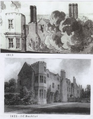
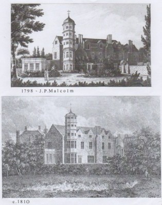
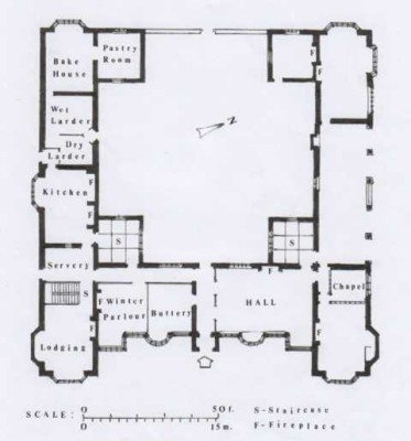
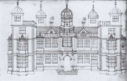
The discovery in 1782 by Horace Walpole of a book of architectural drawings of Elizabethan and Jacobean date (Summerson 1966 The Book of Architecture of John Thorpe in Sir John Soanes Museum in The Walpole Society #40) helps to give some definition to the likely plan and appearance of Clerkes building, even though so little survived to be recorded 200 years later. Summersons comprehensive study of this material would suggest that Clerkes mansion belongs to a type of H or half H plan fashionable in Surrey in the last quarter of the 16th century and typified by Wimbledon House built in 1588. This plan type is characterised by two opposing square staircase towers built as extruded corners. These were matched by two others at the end of the wings. (At Clapham Place these latter staircases took the form of Viewing Towers see above). A curious feature, seen for example in the Malcolm 1798 (Fig. 8) and Buckler 1823 (Fig. 9) prints, indicates that the two eastern bays of the range have fenestration and gables that differ from those (presumably original) at the west end. It suggests that when the hall complex was pulled down, the adjacent wall on this wing was rebuilt with roughly matching windows, but closer together and not aligned with the earlier work.
No illustration of Clerkes mansion has been identified to my knowledge in Thorpes catalogue or indeed elsewhere. The plan and elevation provided here (Figs. 12 and 13) are both of different buildings illustrated by Thorpe which give a general idea of the likely layout and appearance of Clapham Court in its heyday. It will be noted that the ground floor of one wing of Canons c. 1604) (Fig. 12) was entirely given over to a well-planned kitchen facility. A similar arrangement at Clapham may have incorporated the rooms of the kitchen complex mentioned in the 1628 Extent. At Clapham it is likely that it was the north range, facing the farmyard, that was used for the kitchen premises (i.e. that shown on the 18th and 19th century prints). This is supported by the geophysical results in Areas 3 and 4, which probably show wall foundations relating to the former hall range (Fig. 10).
The front elevation of Noseley Park c. 1604 (Fig. 13) from Thorpe does not tie in exactly with Canons plan, but gives a good idea of the likely appearance of the east front of Clapham Court.
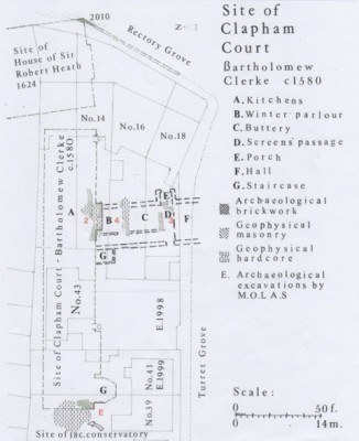
The Hall range (Fig. 10)
A study of Elizabethan great houses indicates an almost stereotype plan, particularly in the London area. The middle range is entered centrally through a projecting porch into a cross passage called the Screens Passage. On the side facing the hall was the ornamental wooden partition or screen usually with 2 or 3 openings. Above it was the minstrels gallery. The hall at this period had elaborate fenestration, a wall fireplace and access from the high table end to the private apartments. Those included at Clapham Court a (private) dining chamber well wainscotted i.e. panelled. These arrangements are clearly shown on John Thorpes plan of Canons (Fig. 12). On the other side of the Screens Passage were a group of important service rooms, to be described below.
The critical question at Clapham is where was the hall in relation to the range that survived to the 19th century? The clue lies in the nature of the huge chimney stack on the south side of the Clerke range. Normally the projecting chimney stacks of a 16th century lodging range would be on the back of the building. In the case of Clerkes wing this would have meant that in theory it should have been on the north side of the range, yet the old prints (Figs. 8 and 9) clearly show that it was on the south side. This indicates that, together with its size, this was not a lodgings chimney stack but one that served the kitchens of the establishment, and that it may have had in addition a secondary purpose which made it necessary for it to be in this position. At Clapham, then, this is the arrangement with the kitchen complex and service rooms at the north end of the hall range, with the hall itself and private apartments at the southern end facing the gardens. The Canons plan (Fig. 12) shows the arrangement clearly, although reversed.
The geophysical survey showed two lengths of cross wall (Figs. 7 and 10) suggesting two rooms with a corridor on the west side linking them to the service wing. Because Elizabethan planning was so uniform, it is possible to guess the names and functions of both rooms which were the office/workplace of the two most important officials of the household, namely the Steward and the Butler. Both rooms were carefully positioned between the service quarters and the public/private apartments.
The Winter Parlour (Fig. 10B)
The Winter Parlour was so named because it was heated all year round. Whether there was a fireplace as such at Clapham is not clear from the geophysical evidence. However, the placing of the room against the chimney breast of the kitchen fireplace (Fig. 10A) would have ensured a steady background heat for the Winter Parlour throughout the year. This was particularly necessary at this period because the building of Clapham Court coincided with the worst downturn of the so-called Little Ice Age (Green 2009 pl. 1). The Steward was more sedentary than most household officials and required a warm room as an office where the management of the establishment and estate was organised and the accounts kept. Household staff would have received their wages here. In many respects it was the equivalent of the Hosts Room or Common Parlour at Clapham Place (Green 2009, 193).
The Buttery (Fig. 10C).
This large room with direct access to the Screens Passage was the preserve of the Butler. This official was the head-servant of the household with overall responsibility for the purchase and production of the food, and in particular the care and presentation of expensive items such as wine. At Clapham Court there was good cellarage where presumably the bulk of the beer would have been stored. In the Buttery room the wine and other delicacies would have been prepared for table at feasts, over which the Butler presided in the hall. The site of the hall itself was not examined by the geophysical survey. It lay beneath the street of Turret Grove. The postulated site of the south wing probably lay beyond under the houses and gardens of Nos. 20 and 22 Rectory Grove.
The demolition of Clapham Court
The circumstances surrounding the demolition of the hall range and south wing are now no longer clear. No manor house symbol for Clapham is shown on the Road Map of 1675 by John Ogilby, so it is likely to have gone by then. The manor was acquired by Dr Henry Atkins c. 1616-17. The Atkins family were of a different stamp from earlier manorial owners and were inclined to have absolutely no nonsense with the Clapham community. In 1624 the parish lost the use of the manorial hall as a Court Leet for the business of the manor. This formally marked the end of the thousand-year role of the Lords of the Manor as leaders of the Clapham feudal community. By 1628 Atkins had appropriated the water from the spring under what is now Holy Trinity Church, which had served the village community in Old Town. He diverted it in lead pipes to serve the manor and water its gardens. As a result the village community had to trudge half a mile along North Side to draw water from Springwell. Compounded with this antisocial action was the destruction of the 70 acres of Stockwood for conversion to pasture and arable land, which had been achieved by the time of his death in 1639. By this action the village community lost the right of pannage (the right of feeding swine in woodland). It is hardly surprising that the Atkins family dynasty acquired the lasting dislike of the Clapham community.
The Civil War and Commonwealth interregnum (c. 1642-1660) was a troubled time for Royalist Lords of the Manor, and there is no doubt that the Atkins family were in seriously straightened circumstances. The Commonwealth republican regime (1649-1660) was particularly difficult with no obvious likely change ahead. I believe that it was during the 1650s that the hall range and south wing was demolished, leaving the Atkins family with the north wing for strictly domestic use. The building materials were reused for the construction of lettable properties on manorial land in Clapham.
CLAPHAM PLACE
Unlike the locations of the Norman and Elizabethan manors, whose exact sites were uncertain until the geophysical exercise carried out by Stratascan pinpointed their positions, much has recently been discovered about Clapham Place, and was published in Historic Clapham in 2009. The house is of interest not least because visited by such luminaries as Aubrey, Evelyn and Pepys, who indeed spent the last three years of his life as the guest of the then owner.

The site
Intensive research work was necessary because the mansion, built c. 1666 by Dennis Gauden (knighted for his public services during the Great Fire of London) was pulled down c. 1762, and all memory of its site and appearance had been lost for over two hundred years. So thoroughly had the site been disturbed that the draft of the Ordnance Survey map of Clapham (1804-6) shows the house location merely as a demolition pit (Fig. 14).
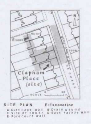
Providentially building work at the rear of No. 13 The Chase in 2003 (Fig. 15), and a Thames Water service trench along The Chase, revealed the east side of the mansion in 2008 (Fig. 16), confirming its postulated position (Green 2009, 183-185). All that remained to be gained from the geophysical exercise was to confirm the exact position of the flanking towers of the north front, trace the extent of the north east service range of the courtyard and identify as much of the internal arrangements as had survived the later 18th century demolitions. Of particular importance was to see whether any distinguishing features had survived which might identify the plan with the mansion shown on a painting by Robert Streater c. 1662-4 (Fig. 17).
The Geophysical Survey in 2011
The roadway and pavement on the western side of The Chase was extensively examined between Nos. 5 and 13, notwithstanding parked vehicles outside Nos. 5-7. The front and rear gardens of No. 9 (Mr David Treherne-Pollock) and the rear garden of No. 7 (The Hon. Mrs Thomas Sackville) were tested. Notwithstanding the structural robbing of the building in the later 18th century, important discoveries were made on all these sites. I am greatly indebted to the owners for allowing the geophysical surveys to take place, and particularly to Mr Treherne-Pollock for coordinating and facilitating the survey. It had been hoped to survey the front and back areas of No. 5, which covered the front rooms of Clapham Place, but unfortunately the ground level had been lowered on both sides in modern times making this impossible.
As the survey results make all too clear, only fragments of the walls and floors survived (Fig. 18). Fortunately the 2008 excavations indicated that the brick outer walls of the house (13½ inches wide) still remained to a height of 2 ft. in places, and where there were junctions with load-bearing internal walls these could also be traced. The floor of the semi-basement of Clapham Place was found to be only 3 ft. below the modern road surface, indicating probable denudation of the 17th century ground levels in this area of The Chase when the building remains were robbed (Fig. 18).
The plan-type
As already indicated, most of the east wall of the building had been traced in the 2008 service trench, including the south east corner (Fig. 16). Providentially the geophysical survey identified the outer angles of the two corner turrets on the northern frontage, which enabled the overall dimensions of Clapham Place to be accurately plotted (Fig. 18). The origins of this plan-type and the problems of the possible architect, Sir Roger Pratt, are discussed at length in Historic Clapham (Green 2009 chapters 9-11). Its general size and proportions place it firmly within a certain class of Restoration House with a triple-pile plan, of which Eltham Lodge (begun 1664) is a close parallel in general design terms as well as date (Summerson 1953, 116-117).
The unusual corner turrets or viewing towers are not part of the Netherland repertoire from which this type of country-house style drew its inspiration, but are found amongst Jacobean country houses in Middlesex. Bruce Castle, Tottenham and Hall Place at Bexley are typical mid 17th century examples (Knight 2009, 18 and 69). In the immediate vicinity of Clapham there was Canon House, a late 16th century mansion pulled down between 1863-5 which had distinctive corner towers with cupolas. The corner towers of Vauxhall Manor House also had cupolas (Cole and Borg 1911, 11 and 14).
The Streater picture
That Clapham Place also possessed corner towers was established from a vignette of Clapham Place on John Ogilbys Road Map of 1675, the Road from London to Portsmouth. The next question was: Is there a view of a Restoration House with Jacobean or older corner towers? It was Alyson Wilson who discovered such a picture attributed to Robert Streater and dating to c. 1662-4 (Green 2009, 186). The clinching evidence for attributing the Streater painting to Clapham Place was the unusual architectural treatment of the facade shown in the picture. It had reticulated window bay treatment, with the window bays projecting 2-3 feet in front of the south elevation (Fig. 19). A particular effort was made to identify this feature when the geophysical survey took place. Only part of the southeast frontage of the house was available for study, hampered by two parked cars. Usefully, the exact position of the southeast corner of the building had been established archaeologically, in relation to the modern topography (Figs. 15 and 16). However the second bay westwards was shown from the geophysical survey to be set back 3 ft.. Better evidence would have been desirable, but I think that the case for identifying Clapham Place with the Streater painting is now sufficiently strong to confirm the hypothesis.
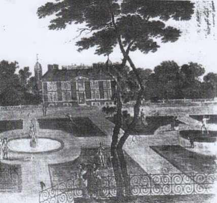
The hexagonal brick turrets
These have now not only been located, but can be seen to be smaller than originally postulated (Fig. 19), and to this extent bear comparison with those shown in the Streater painting (Fig. 17). The distinctive appearance of the turrets red brick with stone dressings, window openings and cupola lead roofs mark them out as of early Tudor date. The house, originally a hunting lodge, to which they originally belonged first appears in a conveyance of 1503 and was called Brick Place. Gauden converted the turrets for use as service stairs. The excavations in 2008 indicated that they had probably been demolished before the building was finally pulled down in 1762 (Fig. 16).
CLEAR
The overall plan
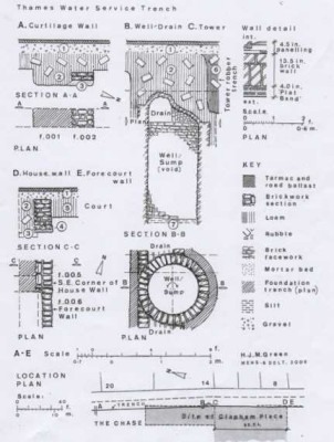
As defined by the new evidence the house is approximately 104 ft. long and 60 ft. wide; slightly smaller than that quoted in the Clapham Society Newsletter (No. 345). The extension of the survey area by Stratascan in August 2011 to the north along The Chase was to trace the east wing of the north (back) courtyard. A length of north/south wall was identified as the west wall of the east wing, with an extensive area of paving on either side. The east wing is now revealed as being 35 ft. in length and only about 15 ft. in width: (the east side was identified in service trenches in 2008) (Fig. 18). At the southern end of the east wing the 2008 excavation also revealed an intact brick well or sump served by an east-west drainage system (Fig. 16). The modest size of the east wing suggests that it may have been a stable range of the Garden establishment. The same is also probably true of the west wing whose west wall was discovered in 2003 (Fig. 18).

As noted above the geophysical survey has also tweaked the plan of the building generally. For example, the Long Gallery is now seen to be about 8 ft. wide rather than 12 ft.. Traces of the substructure of the eastern flight of steps from the court were also discovered (Fig. 18). One of the most important discoveries of the geophysical survey was that the central staircase hall was much smaller than originally postulated, which had been based on John Aubreys sketch plan. (Green 2009, 177). Evidently the width of the staircase hall was about 17 ft., rather than 37 ft.. It was still wide enough to take a 7 or 8 ft. wide flight of stairs, with a landing at the north end, under which was the north entrance (Fig. 19). The two great rooms on the north side can now be seen to have been the fashionable double cube of the period. The large block of footings in the kitchen (under the Store Room (Fig. 19) was probably for a central kitchen range similar to that shown in a 17th century print (Green 2009, 194).
SUMMARY
The three Clapham mansions discussed in this report represent in microcosm the architectural development of great houses in England from about 1100 to 1700 a critical period. Three phases can be detected, remarkably reflected by each building: an emphasis on security (represented by the Faramus hall-house; on display (Clerkes Clapham Court); and comfort (Gaudens Clapham Place). To a large extent this reflects more settled social conditions, but also a response to the worsening weather conditions of the Little Ice Age, and the need to conserve heat.
Considering how little definite information was known about these buildings until recently or indeed the site of old Holy Trinity Church (now St Pauls), it is greatly to the credit of our local historians, the financial support of the Clapham Society, together with the work of the Stratascan team, that our knowledge of these ancient buildings has been so totally transformed.
June 2012
Bibliography
Cole D. and Borg, A, Vauxhall Gardens, 1911
Green, H.J.M, Historic Clapham, 2009
Knight, C, Londons Country Houses, 2009
Summerson, J, Architecture in Britain 1530-1830, 1953
Wood, M, The English Medieval House, 1965.